ENTIAT, Wash. — Firefighters are working to get control of the Pomas Fire burning in the Glacier Peak Wilderness near Entiat.
As of Thursday afternoon, it’s burned 910 acres.
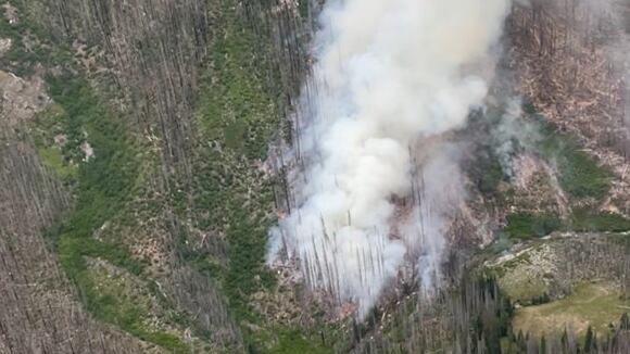
The fire started on June 13 and crews believe lightning is to blame.
Crews say winds continue to spread the fire, which has moved north into Ice Creek and northeast into Aurora Creek just west of Borealis Peak.
Right now, firefighters are looking for opportunities to use containment lines from past fires in the vicinity to help, such as the 2015 Wolverine Fire.
Over 377,000 gallons of water have been dropped on the fire, and crews will be wrapping key infrastructure, such as the Myrtle Lake bridge, with protective fire-resistant materials over the next few days.
Evacuations
None, there are no structures or homes threatened at this time.
Closures
The Glacier Peak Wilderness on the Entiat Ranger District, including Ice Lakes, is now closed for fire operations and public safety.
Mrytle Lake access is also closed. The fire is 12 air miles from the Pacific Crest Trail and currently poses no threat to that trail.
Specific trail closures include:
- Entiat River Trail
- Cow Creek Trail
- Myrtle Lake Trail
- Larch Lake Hiker Trail
- Larch Lakes Trail
- Garland Peak Trail from the saddle south of Fifth of July Mountain to the junction with Pomas Pass Trail
- Pomas Pass Trail
- Ice Creek Trail
- Snowbrushy Trail from the junction with Entiat River Trail to Milham Pass
- 45 Mile Drive Trail
- Duncan Hill Trail from the wilderness boundary to the junction with Snowbrushy Trail
- Anthem Creek Trail
- Pyramid Mountain Trail from Saska Pass to the junction with Snowbrushy Trail
- Cool Creek Trail
- Wilson Creek Trail
©2025 Cox Media Group