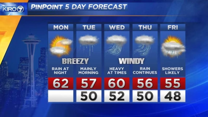
Rain will return to Western Washington in full fall force this week.
A composite image from NASA on Monday shows a solid swath of moisture stretching from coastal China to the coast of British Columbia. Part of this storm is going to hit Western Washington off and on for the entire week, according to KIRO 7 PinPoint Meteorologists.
%
%
“Rain is likely overnight [Monday] and for the Tuesday morning commute and could be heavy in places,” said KIRO 7 PinPoint Meteorologist Nick Allard.
Latest weather headlines
- La Niña could bring another wet and snowy winter to the Northwest
- PHOTOS: Snowy conditions on Snoqualmie, Stevens passes
- Snow falling at Snoqualmie Pass
- Watch StormTracker Doppler Radar livestream here
- How to build an emergency kit on a budget
DOWNLOAD KIRO 7's WEATHER APP HERE
"Winds from the south 15-25 mph with higher gusts, so an active morning. A brief break late day will be followed by another round of rain Tuesday night through most of Wednesday and Thursday. Rain will be heavy at times accompanied by gusty winds,” Allard said.
As of Monday morning, models are inconsistent on how much rain we get — but it could be anywhere from 1 to 4 inches of rain in the lowlands for the period of Monday night through Thursday.
%
%
The mountains will likely get between six and 10 inches of rain.
Friday looks like a break from widespread rain, though showers are likely and we’ll be watching for potential thunderstorms as we move closer to the end of the week.
The six-month period from October through March is undoubtedly the "rainy season" for Seattle and Western Washington.
Cox Media Group