A Winter Weather Advisory has been issued for much of central and south Puget Sound and Winter Storm Warning is in effect for the Hood Canal region.
Snow for some late Saturday before freezing rain threat
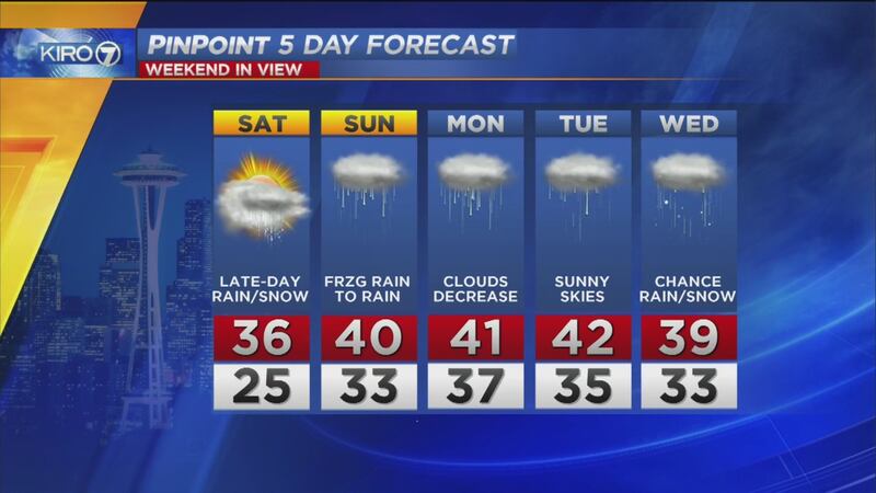
As we transition to a warmer airmass around Western Washington, the threat of frozen precipitation -- snow, freezing rain and then just rain -- are likely.
For most lowland locations, we'll see precipitation start Saturday late in the afternoon or evening as mainly light snow or light rain. Moisture will be pretty limited from about the Seattle area northward, so accumulations of an inch or less are more likely on higher hills and from Pierce County south.
Precipitation will become lighter and more patchy Saturday night into Sunday morning, but at that point as we enter early Sunday morning, temperatures at the surface could well be below freezing. This could mean a period of freezing rain or freezing drizzle where those raindrops falling through the warmer air aloft freeze on contact with sub-freezing road surfaces.
Use extra caution venturing out Sunday morning as less well-traveled roadways and untreated surfaces could be icy. This includes sidewalks! Many injuries occur when people step out of their homes, not seeing a thin glaze of ice on the sidewalks and other areas around their home.
By afternoon Sunday, temperatures in the lowlands will make precipitation just falling in the form of rain with snow levels rising.
Spots that get good snow: Hood Canal and southwestern Washington
A Winter Storm Warning has been issued for Hood Canal and Mason County around Shelton. Cold air gets "trapped" in that region because of topography and we're likely to see accumulating snow in places like Shelton, Seabeck and Belfair late Saturday into Sunday morning before turning to rain late Sunday. %
%
Up to six inches of snow could fall there!
Also, we'll watch for some accumulating snow in the higher elevations of southwestern Washington.
Possibility for more wintry weather mid-week
There are indications that temperatures might be supportive of some lowland or higher hills snow once again around mid-week, but details will come into better focus later in the weekend or early next week.
Check out the latest forecast here, on KIRO 7 News at 5, 6, and 11, streaming at kiro.tv/LiveNews
Follow me on Facebook and Twitter!
Cox Media Group