A blast of cold air making its way across Western Washington brought snow to some areas on Wednesday morning, and more is possible later on.
Thick flurries, enough to form a white blanket of snow, covered parts of King County, which was under a Winter Weather Advisory, along with Snohomish and Skagit counties. The advisory expired at 11 a.m.
Omar Rosa and his family are visiting Bellevue from California. Rosa said waking up to snow was a great surprise.
“We bundled up and said, ‘Let’s go outside, it’s the first time the girls have seen snow,’ so we were like ‘Let’s go out there and see what it’s like,’ and yeah, it’s been fun, it’s cold,” said Rosa.
Some were surprised to see snow this late in the season.
“To see it’s still snowing I was kind of like, ‘Umm, not what I expected going into March in a week and a half,’” said Jaime, also in Bellevue.
In the North Sound, snow caused disruptions for families as a handful of school districts delayed classes. Snowy roads caused schools in the Lake Stevens School District to delay the start of classes by two hours.
As snow fell, collisions started piling up.
❄️ The PNW in #SnohomishCounty experienced snow this morning. Remember with adverse weather conditions to:
— Trooper Kelsey Harding (@wspd7pio) February 22, 2023
⬇️ Slow down
🚘 Increase following distance
⏰ Give yourself extra time
This morning #SnohomishCounty troopers had 16 collisions and 11 disabled or abandoned vehicles pic.twitter.com/O5tymEC1xX
Bothell police responded to multiple crashes around Nike Hill, causing 228th Street to close in both directions.
Just east of Everett, troopers shut down an eastbound Highway 2 offramp because of numerous crashes and spinouts.
Closer to Lake Stevens, the snow caused major traffic jams on highways, with cars lining roadsides.
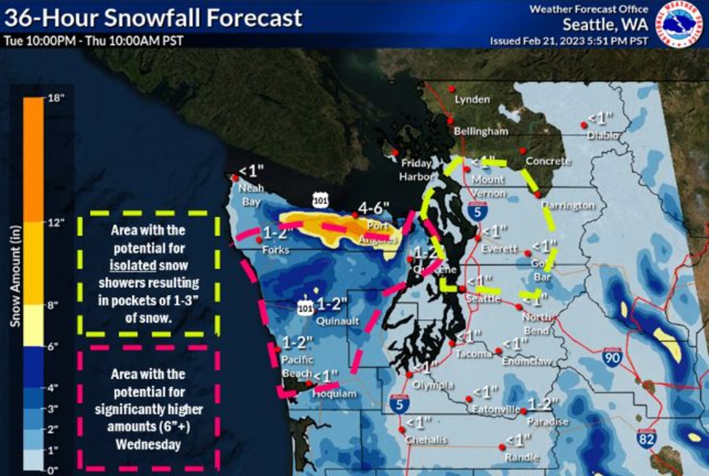
Forecast
One band of snow moved through the area Wednesday morning that is now pushing over Island and San Juan counties, over to Clallam County.
We will see some spotty snow showers here and there, with the majority of what’s left falling over Clallam County thanks to very strong northeast wind out of the Fraser River.
Wind gusts around Bellingham were around 58 mph. Not only is that very strong, but with temps in the upper 20s, it feels like it’s in the teens. The upper-level low that produced the band of snow in the morning is still spinning around to our south and there is another round of snow hitting the Portland-Metro area into Southwest Washington.
See photos from around Western Washington below.
0 of 23


Computer models show the snow moving north and increasing over our area Wednesday afternoon, mainly west of Puget Sound. However, this bears watching because some of this moisture may move over Thurston, Pierce, King and Snohomish counties this afternoon and evening.
We do have some breezy northeast wind which should help push drier air in to “eat” some of the falling snow. If this band ends up being just a bit farther east than forecasted, we would get some more widespread snow showers. At this point, we only have Winter Weather Advisories for the coast, the Southwest Interior of the state, and the Olympic Peninsula into Port Angeles.
There will be some lingering snow showers overnight, with some flurries Thursday morning. Thursday will be dry and sunny but breezy, with highs only barely breaking freezing for Seattle, with lows in the teens to low 20s. Friday also looks dry and cold.
Temperatures start to moderate over the weekend as moisture returns, mainly later Saturday and Saturday night. There could be some wet snow and mainly minor accumulation over the weekend before it turns to all rain in the lowlands by Sunday afternoon.
Chances of morning wintry mix with later-day rain continue Monday and Tuesday, though temperatures moderate with highs in the 40s and lows in the 30s.
©2023 Cox Media Group


