SEATTLE — Tuesday marks 22 years since the magnitude 6.8 Nisqually earthquake shook Western Washington.
On Feb. 28, 2001, at exactly 10:54:32 a.m., the earth beneath Western Washington shook so hard that buildings crumbled, roofs caved and the ground split open.
The magnitude 6.8 earthquake lasted just 45 seconds, but it felt like an eternity to those who rushed to take cover.
In less than a minute, the quake would cause hundreds of injuries and millions of dollars in damage.
The Nisqually earthquake resulted in one death, a person who died from a heart attack.
Western Washington rocked
A former KIRO 7 reporter and KIRO 7 Chief Photojournalist Scott Crueger were in the mayor’s conference room on the 12th floor in the old Seattle City Hall when their story for the day instantly changed.
Their quick action brought some of the first live pictures of the quake to viewers in Seattle, and eventually, around the world.
Just one mile north, parts of the ceiling at the Westin Hotel crashed down on dozens of people packed in a ballroom for a technology conference. It interrupted Microsoft’s co-founder, Bill Gates, in the middle of demonstrating the new Windows XP program.

In Pioneer Square, buildings crumbled and sent bricks and debris onto parked cars.
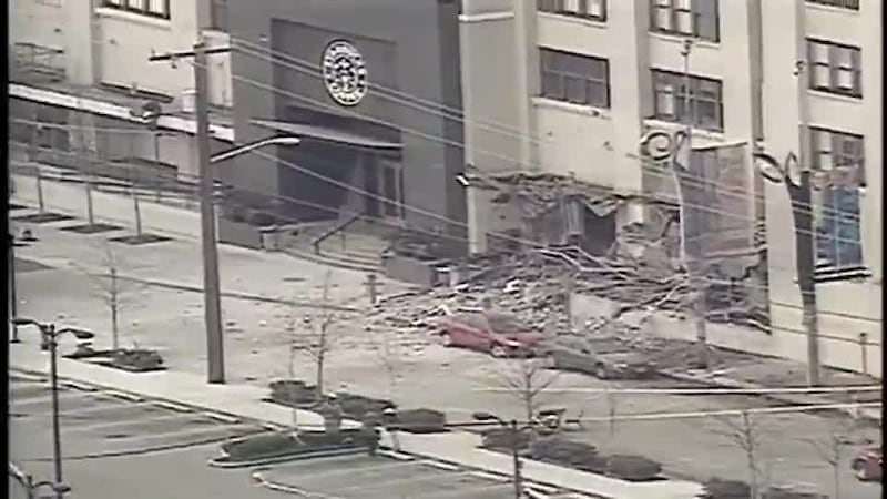
Parts of the iconic Starbucks Center in SoDo crashed to the ground.
The South Sound took the brunt of the damage.
In Olympia, the state Capitol building cracked, and chandeliers swayed as the ground rumbled.
One witness described the chaotic scene in the Capitol building as people ran for their lives. “People were running down the hallways. I could hear people screaming downstairs, ‘Are you OK? Get out of the building.’ Obviously, a lot of panic,” said Burke Long.
Across the street from the Capitol, the state supreme court’s chief justice was meeting with Mongolian dignitaries. He quickly ushered them to a doorway for safety.
Just five miles east in Lacey, food flew off the shelves at a Megafoods Grocery Store as workers calmly and quickly ushered customers out of the building.
0 of 32


In Maple Valley, neighbors dealt with a much different disaster caused by the quake.
Seconds after the earthquake, a landslide barreled down toward the community. It took out homes and even trapped some neighbors inside.
Debris from that landslide filled a channel of the Cedar River, causing flooding upstream.
Airports and bridges across Washington had to close for inspection and repairs.
In all, the 2001 Nisqually earthquake caused between $1 and 4 billion in damages.
Lessons learned
The earthquake’s epicenter was 32 miles below Anderson Island, which helped buffer some of its force, but it could still be felt as far away as Vancouver, Montana and Portland.
It did serve as a warning to the state.
Since the quake, seismic retrofitting work has been done on Washington bridges.
A recent study by structural engineers at the University of Washington found most bridges will be able to withstand up to a magnitude 9 earthquake.
“We found that the damage to bridges is much lower than expected,” explained Professor Marc Eberhard. “For the vast majority of bridges in the region, we think they will be just fine.”
King County relocated its state-of-the-art emergency operations center to Renton, where it sits on top of a ridge of solid bedrock and has 800MHz radio communication to nearly all of King County.
Major buildings, schools and hospitals made upgrades to better protect infrastructure.
Harold Tobin of the Pacific Northwest Seismic Network is concerned more work must be done. The seismologist is particularly concerned about unreinforced masonry.
“We have great codes for new construction, but we don’t have codes that require older buildings to be retrofitted,” said Tobin.
According to local historian, Feliks Banel, many buildings in Seattle’s Pioneer Square neighborhood fall short of meeting present-day seismic safety codes.
“Brick buildings that don’t have any rebar or don’t have anything tying them together,” said Banel. “This neighborhood when the really big quake comes, this will just be a disaster.”
Science has advanced with new tools to better track the activity and monitor what is going on below the surface.
Tobin says in the two decades since the disaster, the number of seismic stations in the area has more than doubled.
In May of 2021, Washington Emergency Management launched an alert system to warn people on their phones, similar to a weather alert or Amber Alert.
The ShakeAlert Earthquake Early Warning System is available for mobile phones in Washington and may provide vital seconds of warning needed to alert people that an earthquake is about to happen.
The system uses a network of sensors that detect the start of an earthquake and calculates the magnitude, location and expected amount of shaking from earthquakes on the West Coast.
It sends the information in real time to distributors that send out alerts to cell phones and the internet.
Washington state has the second-highest earthquake risk in the United States. It also has one of the highest tsunami risks.
The system is designed to give residents time to take cover in the event of an earthquake but it cannot predict when an earthquake will strike.
State officials say it’s important that people enable emergency alerts on their phones so they can receive the alerts.
Details on how to do that can be found here.
©2023 Cox Media Group


