
Icy and rainy weather is still rolling through Western Washington.
As Thursday morning temps reached the low to mid-30s, commuters dealt with icy and slick roads, especially in the North Sound and Whatcom County areas.
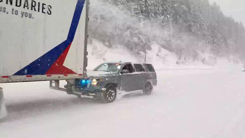
⚠️ Cascade Pass travel still a bit challenging today.
— Snoqualmie Pass (@SnoqualmiePass) January 18, 2024
❄️ Steady snow Thursday morning to Thursday night. 5-10" of snow expected with the heaviest snowfall between 6-10pm. 40 mph wind gusts may reduce visibility through Thursday evening.
♥️ Safe travels pic.twitter.com/jzbZhiKw4D
>>KIRO 7 Pinpoint Weather Forecast
Snow is continuing to fall in Whatcom County Thursday, with several schools closed for the day across the region. Icy sleet and freezing rain have also rolled through parts of the North Sound as well as around North Bend and Snoqualmie.
Whatcom County has seen a changeover to rain, which could cause problems due to flooding.
Most of the precipitation south of there has been falling as rain, but there will probably be some snow or wet snow mixed in with the isolated potential for some freezing rain.
KIRO 7 Pinpoint Meteorologist Nick Allard believes you will see more rain than wintry precipitation, but it’s the patchy areas which are still icy that worry him.
The larger concerns will be windy conditions across the Puget Sound region, which could lead to downed power lines and outages between Thursday afternoon and Friday morning.
Puget Sound Energy customers in North Bend have already been feeling that strain after thousands lost power for nearly 24 hours between Wednesday and Thursday night.
This cold air coming from the mountains is also causing icing problems, with about an inch of ice accumulation around Gold Bar, according to the National Weather Service.
KIRO 7 Chief Meteorologist Morgan Palmer expects the ice to be worst in areas adjacent to the mountains.
“Pass travel is going to be very tricky into the morning,” said Morgan.
Wind from the east will keep the Cascade Foothills cold where a messy mix of rain and snow could cause more problems for travelers.
WSDOT crews are now warning drivers that “mother nature’s not done with us yet,” particularly as snow has continued to fall between Forks and Port Angeles.
Whatcom County and the San Juans are still dealing with some snow. As a warm front moves northward, we’ll get some rain mixing in though little or no melting of snow into the morning.
Mother nature's not done with us yet. It's still snowing between #Forks and #PortAngeles. Crews are working around-the-clock to treat roadways. This is SR 113 between US 101 and Clallam Bay this morning.
— WSDOT Tacoma (@wsdot_tacoma) January 18, 2024
- Give us room
- Don't crowd the plow
- Expect conditions to change rapidly pic.twitter.com/dhJl2E04Rl
There is a Winter Weather Advisory for the Foothills, including Lake Stevens, Snohomish, North Bend, Maple Valley, and Black Diamond.
In the Cascades, another foot of snow could fall during the day Thursday.
A Winter Storm Warning is also up for locations nearer the foothills and the Cascades as well.
In Whatcom, Skagit, and Island counties, cold air will hang on later in the day Thursday and we’ll once again likely get a few inches of snow late morning through at least mid-afternoon.
Friday through the weekend, you should expect milder temperatures with highs in the 40s and rain every day.
Rivers will be spiking higher and we might see some minor flooding on the Skokomish River. Mountain snow will fall but perhaps mixed with rain at times at Snoqualmie Pass.
Given the extensive cold temperatures followed by days of heavy rain at times, road problems like fractures and potholes will make themselves evident in the coming days.
But there is no return of Arctic air evident on long-range forecasts once we’re out of the freezer late Thursday into Friday.
From Friday night into Saturday looks dry with highs in the 40s.
Heavier rain is expected to arrive Sunday through early next week. While snow will be melting up north, we could see flooding issues from lack of drainage.
Next week will be mild and wet with highs in the 50s and lows in the 40s with the possibility of more mountain snow.
©2024 Cox Media Group


